|
Aerial Photo of Garfield Basin
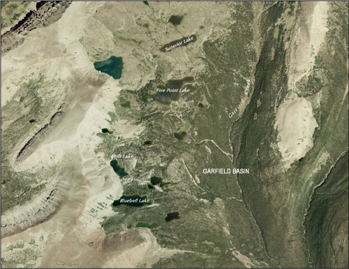 Garfield Basin Lakes such as Bluebell, Drift, Five Point and Superior were once natural glacial lakes. In the early 1900s, they were selected to store irrigation water for the Uinta Basin and all were impounded by the late 1920s, early 1930s. The dams were significant individual resources, as well as components of a much larger irrigation network. Today, they are monuments to the pioneering efforts of the Farmers Irrigation Company to increase the Uinta Basin’s agricultural potential. Farmers Irrigation Company has played a prominent role in the Basin’s economic growth and development. Garfield Basin Lakes such as Bluebell, Drift, Five Point and Superior were once natural glacial lakes. In the early 1900s, they were selected to store irrigation water for the Uinta Basin and all were impounded by the late 1920s, early 1930s. The dams were significant individual resources, as well as components of a much larger irrigation network. Today, they are monuments to the pioneering efforts of the Farmers Irrigation Company to increase the Uinta Basin’s agricultural potential. Farmers Irrigation Company has played a prominent role in the Basin’s economic growth and development.
The historic dams at these reservoirs embodied a style and type of architecture associated with the formative years of water impoundment in the High Uintas. They are considered nationally significant cultural resources and are eligible to be listed on the National Register of Historic Places based upon age, integrity and other National Register criteria.
 Due to substantial deterioration and risk of eventual failure of the dams, Bluebell, Drift, Five Point, and Superior reservoirs were breached and stabilized in 2009 to assure safe conditions and to restore approximate natural lake levels. In an effort to mitigate adverse effects of the stabilization process on cultural resources, substantial documentation of these dams with archival photography was carried out. It was also required that a portion of these dams remain intact. Interpretive displays reflecting the rich prehistory and history of the High Uintas were developed and placed at the Center Park trailhead. Due to substantial deterioration and risk of eventual failure of the dams, Bluebell, Drift, Five Point, and Superior reservoirs were breached and stabilized in 2009 to assure safe conditions and to restore approximate natural lake levels. In an effort to mitigate adverse effects of the stabilization process on cultural resources, substantial documentation of these dams with archival photography was carried out. It was also required that a portion of these dams remain intact. Interpretive displays reflecting the rich prehistory and history of the High Uintas were developed and placed at the Center Park trailhead.
Follow the links below to learn more:
BLUEBELL LAKE
DRIFT LAKE
FIVE POINT LAKESUPERIOR LAKE
BLUEBELL LAKE DAM: Dam Completed in 1930 - Stabilization Completed in 2009 [PHOTOS]
Statistics (before stabilization)
Location: Approximately 11.2 miles northwest of Swift Creek Campground
Elevation: 10,894 feet
Dam Length: 230 feet
Dam Height: 8 feet
Dam Width: 7 feet
Dam Type: Earth fill with rip-rap stone face
Dam Builder: Farmers Irrigation Company
Reservoir Size: 47.2 acres; 258 acre-foot capacity
Maximum Reservoir Drawdown: 6 vertical feet
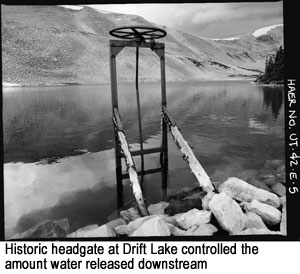
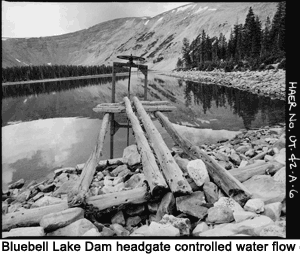 History: Bluebell Lake was a natural pool of water at the base of a rock slide-ridge that forms the western wall of Garfield Basin. By July 1926 Farmers Irrigation Company obtained water storage rights for Bluebell Lake. By 1930, an earthen-fill dam was built across the northeastern outlet of the Lake. No modern modifications were made to the historic dam, spillway or downstream outlet. However, the upstream gate was replaced and the steel outlet pipe was slip- lined with a smaller diameter, high-density polyethylene (HDPE) pipe in the 1980s. History: Bluebell Lake was a natural pool of water at the base of a rock slide-ridge that forms the western wall of Garfield Basin. By July 1926 Farmers Irrigation Company obtained water storage rights for Bluebell Lake. By 1930, an earthen-fill dam was built across the northeastern outlet of the Lake. No modern modifications were made to the historic dam, spillway or downstream outlet. However, the upstream gate was replaced and the steel outlet pipe was slip- lined with a smaller diameter, high-density polyethylene (HDPE) pipe in the 1980s.
National Register Determination: The historic Bluebell Lake Dam is a significant individual resource and is a component of a much larger irrigation network. Prior to stabilization, no modern modifications had been made to the dam, maintaining its form and function, providing flow to an existing historic irrigation system.
The historic dam at Bluebell Lake was evaluated in 1985 for eligibility to the National Register of Historic Places and was determined eligible under Criteria A (associated with events that have made a significant contribution to the broad patterns of our history) and C (embodies the distinctive characteristic of a type, period, or method of construction).
 For a full description of Bluebell Lake Dam [click here to download the Cultural Resource Inventory of Farmers, Deer, White Miller, East Timothy, Water Lily, Five Point, Drift, Bluebell and Superior Lakes.] Click here to view Historic American Buildings Survey/Historic American Engineering Record (HABS/HAER) documentation and photos. For a full description of Bluebell Lake Dam [click here to download the Cultural Resource Inventory of Farmers, Deer, White Miller, East Timothy, Water Lily, Five Point, Drift, Bluebell and Superior Lakes.] Click here to view Historic American Buildings Survey/Historic American Engineering Record (HABS/HAER) documentation and photos.
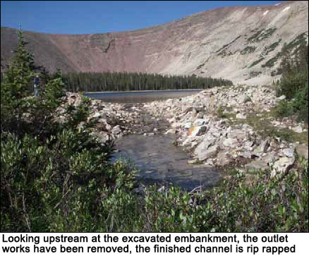
Stabilization Process: The Lake was stabilized in June/July 2009. Crews removed the historic headgate and excavated the main embankment to the top of the outlet pipe. A temporary earthen coffer dam was placed and the entire outlet pipe and head structure were removed using a combination of hand tools and mechanized equipment. The outlet channel through the
breach was rebuilt using rock sills. Riprap was placed in and along the channel to protect it from scour.
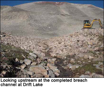
DRIFT LAKE DAM: Dam Completed in 1928 - Stabilization Completed in 2009 [PHOTOS]
Statistics (before stabilization)
Location: Approximately 11.4 miles northwest of Swift Creek
Campground
Elevation: 11,064 feet
Dam Length: 235 feet
Dam Height: 12 feet
Dam Width: 5 feet
Dam Type: Earth fill with stone rip rap facing
Dam Builder: Farmers Irrigation Company
Reservoir Size: 24.8 acres; 197 acre-foot capacity
Maximum Reservoir Drawdown: 9 vertical feet
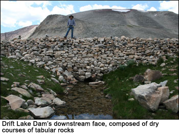 History: Drift Lake was a small and narrow natural pool of water at the base of a rock slide-ridge that forms the western wall of Garfield Basin. By July 1926, Farmers Irrigation Company obtained water storage rights for Drift Lake. By 1928, an earthen-fill dam was built across the southeastern outlet of the lake. The final dam was twice as long and five feet higher than was originally recommended by the Forest Service, which substantially increased the lake's bottom. There were no modern modifications made to the historic dam, spillway or downstream outlet. However, the upstream gate was replaced and the steel outlet pipe was slip-lined with a smaller diameter, high-density polyethylene (HDPE) pipe in the 1980s. History: Drift Lake was a small and narrow natural pool of water at the base of a rock slide-ridge that forms the western wall of Garfield Basin. By July 1926, Farmers Irrigation Company obtained water storage rights for Drift Lake. By 1928, an earthen-fill dam was built across the southeastern outlet of the lake. The final dam was twice as long and five feet higher than was originally recommended by the Forest Service, which substantially increased the lake's bottom. There were no modern modifications made to the historic dam, spillway or downstream outlet. However, the upstream gate was replaced and the steel outlet pipe was slip-lined with a smaller diameter, high-density polyethylene (HDPE) pipe in the 1980s.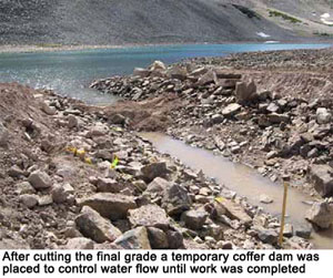
National Register Determination:The historic Drift Lake Dam is a significant individual resource and is a component of a much larger irrigation network. Prior to stabilization, there were no modern modifications made to the dam, therefore maintaining its form and function, providing flow to an existing historic irrigation system.
The historic dam at Drift Lake was evaluated in 1985 for eligibility to the National Register of Historic Places and was determined eligible under Criteria A (associated with events that have made a significant contribution to the broad patterns of our history) and C (embodies the distinctive characteristic of a type, period, or method of construction).
 For a full description of Drift Lake Dam [click here to download the Cultural Resource Inventory of Farmers, Deer, White Miller, East Timothy, Water Lily, Five Point, Drift, Bluebell and Superior Lakes]. Click here to view the Historic American Building Survey/Historic American Engineering Record documentation and archival photos. For a full description of Drift Lake Dam [click here to download the Cultural Resource Inventory of Farmers, Deer, White Miller, East Timothy, Water Lily, Five Point, Drift, Bluebell and Superior Lakes]. Click here to view the Historic American Building Survey/Historic American Engineering Record documentation and archival photos.
Stabilization Process: Drift Lake was stabilized in June/July 2009. Snowdrift first had to be removed from below the dam. Trackhoes were used to remove rocks and excavate a breach. Crews cut through the dam and removed the outlet pipe. Hand crews placed rip rap and washed fines into the channel and placed riprap along the sides of a newly excavated outlet channel.
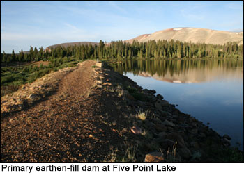
FIVE POINT LAKE DAM: Dam Completed in 1920 - Stabilization Completed in 2009 [PHOTOS]
 Statistics (before stabilization) Statistics (before stabilization)
Location: Approximately 12 miles northwest of Swift
Creek Campground
Elevation: 11,009 feet
Dam Length: 970 feet
Dam Height: 14 feet
Dam Width: 10 feet
Dam Type: Earth fill with rip-rap stone facing
Dam Builder: Farmers Irrigation Company
Reservoir Size: 82..6 acres; 607 acre-foot capacity
Maximum Reservoir Drawdown: 11 vertical feet
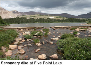 History: By February of 1927, Farmers Irrigation Company obtained water storage rights for Five Point Lake, and by 1929 two dams were built on the Lake. The first dam is a long v-shaped primary earthen-fill dam with a steel pipe outlet; the other, is a small secondary earthen-fill dike. This secondary dike was later fortified with a concrete sill. Both dams are located in the lake’s southeastern end. Five Point Lake is the largest reservoir in the Yellowstone drainage. The two dams comprise the longest retention structure in the Basin. History: By February of 1927, Farmers Irrigation Company obtained water storage rights for Five Point Lake, and by 1929 two dams were built on the Lake. The first dam is a long v-shaped primary earthen-fill dam with a steel pipe outlet; the other, is a small secondary earthen-fill dike. This secondary dike was later fortified with a concrete sill. Both dams are located in the lake’s southeastern end. Five Point Lake is the largest reservoir in the Yellowstone drainage. The two dams comprise the longest retention structure in the Basin.
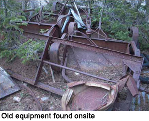 Excellent examples of historic equipment used to build the dams remain at Five Point Lake. These include a horse-drawn earth roller, used to compact soils for the dam, and a horse-drawn earth scraper, used to cut and remove earth for the dam. Excellent examples of historic equipment used to build the dams remain at Five Point Lake. These include a horse-drawn earth roller, used to compact soils for the dam, and a horse-drawn earth scraper, used to cut and remove earth for the dam.
National Register Determination: The historic dam at Five Point Lake is a significant individual resource and is a component of a much larger irrigation network. Although minor modern modifications were made to the outlet works at the dam in the 1940s, these improvements were done in keeping with its general historic feeling. The dam has maintained its form and function, providing increased flow to an existing historic irrigation system. 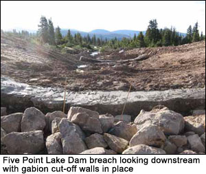
Five Point Lake Dam was evaluated in 1985 for eligibility to the National Register of Historic Places and was determined eligible under Criteria A (associated with events that have made a significant contribution to the broad patterns of our history) and C (embodies the distinctive characteristic of a type, period, or method of construction).
For a full description of Five Point Lake Dam [click here to download the Cultural Resource Inventory of Farmers, Deer, White Miller, East Timothy, Water Lily, Five Point, Drift, Bluebell and Superior Lakes]. Click here to view the Historic American Building Survey/Historic American Engineering Record documentation and archival photos.
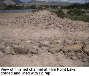
Stabilization Process: The stabilization took place between June and August 2009. The process involved removing the old outlet headworks and grouting shut the existing 24-inch outlet pipe. A v-shaped breach was excavated into the dam to restore outlet flows from Five Point lake to its natural drainage. Rip rap was removed from the upstream and downstream faces of the dam. It's inlet structure was removed and a middle cuttoff wall was installed. Washed fines were placed into and rip rap placed along the new outlet channel.
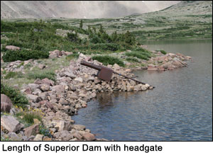
SUPERIOR LAKE DAM: Dam Completed in 1930 - Stabilization Completed in 2009 [PHOTOS]
 Statistics (before stabilization) Statistics (before stabilization)
Location: Approximately 12.4 miles northwest of Swift Creek Campground
Elevation: 11,163 feet
Dam Length: 235 feet
Dam Height: 17 feet
Dam Width: 5 feet
Dam Type: Earth fill rip-rap stone facing
Dam Builder: Farmers Irrigation Company
Reservoir Size: 42.4 acres; 359 acre-foot capacity
Maximum Reservoir Drawdown: 16 vertical feet
History: Superior Lake was originally two small, shallow lakes, with an outlet stream flowing east. By February 1927, Farmers Irrigation Company obtained water storage rights for Superior Lake. By 1930, an earthen-fill dam was built across the southern edge of the lake, doubling the lake's surface area and diverting its outlet stream to the south to flow into Five Point Lake. The Moon Lake Water Users Association made modifications to the historic dam that consisted of rebuilding the original cribbed log support structure for the outlet gate.
National Register Determination:
The historic dam at Superior Lake is a significant individual resource and is a component of a much larger irrigation network. Although minor modern modifications were made to the outlet works at the dam, these improvements were done in keeping with the dam's general feeling. The dam has maintained its form and function, providing increased flow to an existing historic irrigation system.
 The historic dam at Superior Lake was evaluated in 1985 for eligibility to the National Register of Historic Places and was determined eligible under Criteria A (associated with events that have made a significant contribution to the broad patterns of our history) and C (embodies the distinctive characteristic of a type, period, or method of construction). The historic dam at Superior Lake was evaluated in 1985 for eligibility to the National Register of Historic Places and was determined eligible under Criteria A (associated with events that have made a significant contribution to the broad patterns of our history) and C (embodies the distinctive characteristic of a type, period, or method of construction).
For a full description of Superior Lake Dam [click here to download the Cultural Resource Inventory of Farmers, Deer, White Miller, East Timothy, Water Lily, Five Point, Drift, Bluebell and Superior Lakes]. Click here to view Historic American Buildings Survey/Historic American Engineering Record (HABS/HAER) documentation and photos.
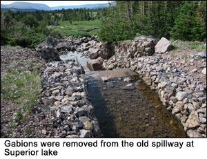
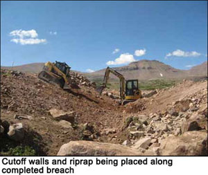
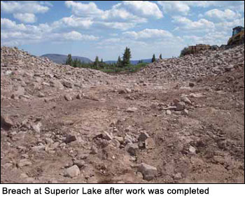 Stabilization Process: Stabilization occurred from June-August 2009. The outlet channel from Superior Lake has been diverted from its natural channel about 0.2 miles downstream of Superior Lake Dam, and a small canal conveyed water into Five Point Lake. As part of the stabilization process, the channel was rehabilitated to restore the outlet flows from Superior lake to its natural drainage. Dam stabilization involved replacing a temporary cutoff dam and removing gabions from the old spillway. Riprap was removed and hand crews, for the most part, removed the old outlet works. The dam was breached in the shape of a v-notch and cutoff walls were installed. A temporary coffer dam was placed and about 10 feet of the outlet pipe was removed on the upstream end. A solid seal on the ends of the outlet pipe was assured through the installation of gabion walls and the pipe was grouted full. As a safety measure, a sand filter was placed at the downstream end of the grouted outlet pipe. The new outlet channel was finished and rip rap was placed along it. Stabilization Process: Stabilization occurred from June-August 2009. The outlet channel from Superior Lake has been diverted from its natural channel about 0.2 miles downstream of Superior Lake Dam, and a small canal conveyed water into Five Point Lake. As part of the stabilization process, the channel was rehabilitated to restore the outlet flows from Superior lake to its natural drainage. Dam stabilization involved replacing a temporary cutoff dam and removing gabions from the old spillway. Riprap was removed and hand crews, for the most part, removed the old outlet works. The dam was breached in the shape of a v-notch and cutoff walls were installed. A temporary coffer dam was placed and about 10 feet of the outlet pipe was removed on the upstream end. A solid seal on the ends of the outlet pipe was assured through the installation of gabion walls and the pipe was grouted full. As a safety measure, a sand filter was placed at the downstream end of the grouted outlet pipe. The new outlet channel was finished and rip rap was placed along it.
|