|
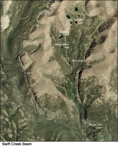
Swift Creek Basin lakes such as Water Lily, Deer, White Miller, Farmers and East Timothy were once natural glacial lakes. In the early 1900s they were selected to store irrigation water for the Uinta Basin, and all were impounded by the 1920s. The dams were significant individual resources, as well as components of a much larger irrigation network. Today, they are monuments to the pioneering efforts of both the Farmers Irrigation Company and the Swift Creek Irrigation Company to increase the Uinta Basin’s agricultural potential. Both companies played prominent roles in the Basin’s economic growth and development.
The historic dams at these reservoirs embodied a style and type of architecture associated with the formative years of water impoundment in the High Uintas. They are considered nationally significant cultural resources and are eligible to the National Register of Historic Places based upon age, integrity and other National Register criteria.
 Due to substantial deterioration and risk of eventual failure of the dams, Water Lily, White Miller, and Farmers were breached and stabilized in 2006. Deer and East Timothy reservoirs were breached and stabilized by 2010 to assure safe conditions and to restore approximate natural lake levels. In an effort to mitigate adverse effects of the stabilization process on cultural resources, substantial documentation of these dams with archival photography was carried out. It was also required that a portion of these dams remain intact. Interpretive displays reflecting the rich prehistory and history of the High Uintas were developed and placed at the Swift Creek trailhead. Due to substantial deterioration and risk of eventual failure of the dams, Water Lily, White Miller, and Farmers were breached and stabilized in 2006. Deer and East Timothy reservoirs were breached and stabilized by 2010 to assure safe conditions and to restore approximate natural lake levels. In an effort to mitigate adverse effects of the stabilization process on cultural resources, substantial documentation of these dams with archival photography was carried out. It was also required that a portion of these dams remain intact. Interpretive displays reflecting the rich prehistory and history of the High Uintas were developed and placed at the Swift Creek trailhead.
Follow the links below to learn more:
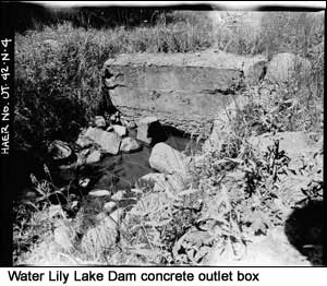
WATER LILY LAKE DAM: Dam Completed in 1920 - Stabilization Completed in 2006 [PHOTOS]
 Statistics (before stabilization) Statistics (before stabilization)
Location: 1.1 miles northeast of Swift Creek Campground
Elevation: 9,600 feet
Dam Length: 64 feet
Dam Height: 10 feet
Dam Width: 4 feet (top); 15 feet (base)
Dam Type: Earth-fill dam with stone rip-rap facing
Dam Builder: Farmers Irrigation Company
Reservoir Size: 22.2 acres; 470 acre-foot capacity
Maximum Reservoir Drawdown: 3 vertical feet
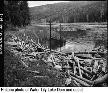
History: By April 1918, Farmers Irrigation Company was granted rights to store 723 acre-feet of water at Water Lily Lake. The reservoir is the oldest and smallest man-made structure in the Swift Creek Basin. Construction at Water Lily began in 1919 and by 1920 a small earthen dam was in place over the outlet at the south point of the lake. Water Lily is the lowest in elevation of all of the reservoirs in the Swift Creek Basin. Water flows from its outlet down 1300 feet where it drains into Swift Creek, just 1.5 miles before it drains into the Yellowstone Watershed. The reservoir was reported as being unused in 1932 and again in 1954, due to its limited storage capacity.
 National Register Determination: The historic Water Lily Lake Dam is a significant individual resource and is a component of a much larger irrigation network. Although minor modern modifications have been made to the outlet works at the dam, these improvements were done in keeping with the general historic feeling of the dam. The dam maintained its form and function, providing flow, while minimal, to an existing historic irrigation system. The historic dam at Water Lily Lake was evaluated in 1985 for eligibility to the National Register of Historic Places and was determined eligible under Criteria A (associated with events that have made a significant contribution to the broad patterns of our history) and C (embodies the distinctive characteristic of a type, period, or method of construction). National Register Determination: The historic Water Lily Lake Dam is a significant individual resource and is a component of a much larger irrigation network. Although minor modern modifications have been made to the outlet works at the dam, these improvements were done in keeping with the general historic feeling of the dam. The dam maintained its form and function, providing flow, while minimal, to an existing historic irrigation system. The historic dam at Water Lily Lake was evaluated in 1985 for eligibility to the National Register of Historic Places and was determined eligible under Criteria A (associated with events that have made a significant contribution to the broad patterns of our history) and C (embodies the distinctive characteristic of a type, period, or method of construction).
 For a full description of Water Lily Lake Dam, [click here to download the Cultural Resource Inventory of Farmers, Deer, White Miller, East Timothy, Water Lily, Five Point, Drive, Bluebell and Superior Lakes Report.] [Click here for record documentation and archival photos in the Historic American Buildings Survey/Historic American Engineering Record (HABS/HAER).] For a full description of Water Lily Lake Dam, [click here to download the Cultural Resource Inventory of Farmers, Deer, White Miller, East Timothy, Water Lily, Five Point, Drive, Bluebell and Superior Lakes Report.] [Click here for record documentation and archival photos in the Historic American Buildings Survey/Historic American Engineering Record (HABS/HAER).]
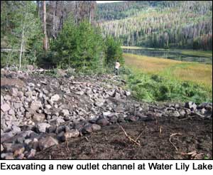
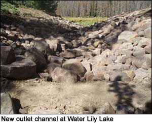
Stabilization Process: Stabilization work at Water Lily Lake begin in August 2006 and took four weeks to finish. The stabilization process required removing the outlet works and constructing of a new spillway in the existing outlet alignment. A v-shaped notch was excavated into the dam (left photo), creating a channel at the lake’s natural lake level allowing water to move naturally again through the watershed. The dam was left intact on either side on the v-shaped notch. The historic headgate, outlet works and pipe were removed and disposed of outside of the wilderness area.
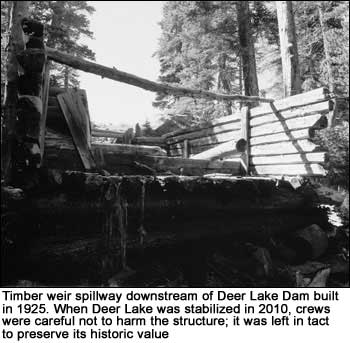
DEER LAKE DAM: Dam Completed in 1925 - Stabilization Completed in 2010 [PHOTOS]
 Statistics (before stabilization) Statistics (before stabilization)
Location: 5.8 miles north of Swift Creek Campground
Elevation: 10,240 feet
Dam Length: 140 feet
Dam Height: 18 feet
Dam Width: 7 feet
Dam Type: Earth-fill dam with stone rip-rap facing
Dam Builder: Farmers Irrigation Company
Reservoir Size: 11 acres; 249 acre-foot capacity
Maximum Reservoir Drawdown: 14 vertical feet
History: By June 1925, Farmers Irrigation Company was granted rights to store water at Deer Lake, with construction of the dam starting immediately. Originally, the Lake was no more than 8 acres in size, but it was relatively deep due to its location between two ridge systems. 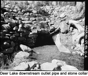
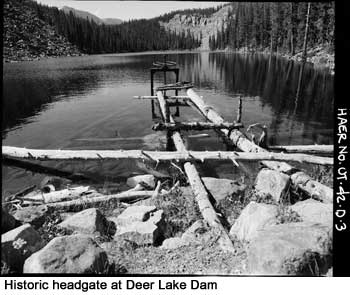
Once the dam was built, the lake increased to 11 acres in size, raising the lake level approximately 14 feet. Deer Lake receives water flow from both Farmers and White Miller Lakes and acted as a regulating reservoir. Associated features include a timber measuring weir and spillway and a stone collar outlet.
National Register Determination: The historic Deer Lake Dam is a significant individual resource and is a component of a much larger irrigation network. Although minor modern modifications required for dam maintenance were made to the outlet works, these improvements were done in keeping with the dam's general historic feeling.
The historic dam at Deer Lake was evaluated in 1985 for eligibility to the National Register of Historic Places and was determined eligible under Criteria A (associated with events that have made a significant contribution to the broad patterns of our history) and C (embodies the distinctive characteristic of a type, period, or method of construction).
For a full description of Deer Lake Dam, [click here to download the Cultural Resource Inventory of Farmers, Deer, White Miller, East Timothy, Water Lily, Five Point, Drive, Bluebell and Superior Lakes Report.] [Click here for record documentation and archival photos in the Historic American Buildings Survey/Historic American Engineering Record (HABS/HAER).]
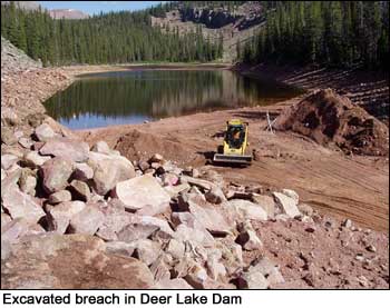
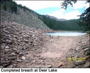 Stabilization Process: Deer Lake was stabilized in the summer of 2010. As part of this project, the outlet works gate and pipe were completely removed and a stabilized
outlet channel was constructed. The stabilization process required removing the stone riprap facing and excavating a breach in the dam. A v-shaped notch was excavated into the dam and a channel alignment was created close to the original natural lake level - allowing water to move naturally again through the watershed. The dam was left intact on either side of the v-shaped notch. Riprap was replaced throughout the entire breach. Stabilization Process: Deer Lake was stabilized in the summer of 2010. As part of this project, the outlet works gate and pipe were completely removed and a stabilized
outlet channel was constructed. The stabilization process required removing the stone riprap facing and excavating a breach in the dam. A v-shaped notch was excavated into the dam and a channel alignment was created close to the original natural lake level - allowing water to move naturally again through the watershed. The dam was left intact on either side of the v-shaped notch. Riprap was replaced throughout the entire breach.
WHITE MILLER LAKE DAM: Dam Completed in 1926 - Stabilization Completed in 2006 [PHOTOS]
 Statistics (before stabilization) Statistics (before stabilization)
Location: 6.9 miles north of Swift Creek Campground
Elevation: 10,380 feet
Dam Length: 105 feet
Dam Height: 3 feet
Dam Width: 2 feet
Dam Type: Stacked fieldstone rock and sod fill
Dam Builder: Farmers Irrigation Company
Reservoir Size: 10 acres; 77 acre-foot capacity
Maximum Reservoir Drawdown: 1.7 vertical feet
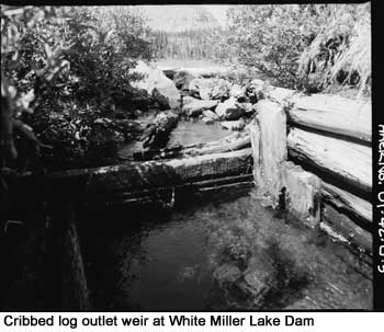
History: By September 4, 1926, Farmers Irrigation Company was granted rights to store water at White Miller Lake. The Lake receives water flow from Farmers Lake and drains into Deer Lake. The dam constructed at White Miller was the simplest of all the dams constructed in the Swift Creek Basin; it consisted of sod and stacked fieldstones and a cribbed log outlet weir. The dam was abandoned in 1959 and, overtime, the dam and outlet became deteriorated and overgrown.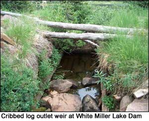
National Register Determination: The historic dam at White Miller Lake was evaluated in 1985 for eligibility to the National Register of Historic Places and was determined eligible under Criteria A (associated with events that have made a significant contribution to the broad patterns of our history) and C (embodies the distinctive characteristic of a type, period, or method of construction). Click here to link to Historic American Building Survey/Historic American Engineering Record (HABS/HAER) documentation and archival photos.
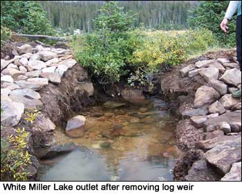
Stabilization Process: Due to the minimal height and width of the old earthen dam at White Miller Lake, the lake had effectively self-stabilized roughly at its natural lake level. The stabilization process required removing a wooden outlet structure and widening the existing spillway to allow water to move naturally again through the watershed. This work was completed in September 2006.
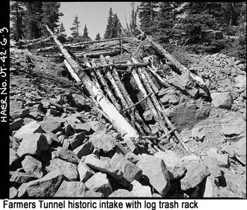
FARMERS LAKE TUNNEL: Completed in 1920 - Stabilization Completed in 2006 [PHOTOS]
 Statistics (before stabilization) Statistics (before stabilization)
Location: 5.7 miles north of Swift Creek Campground
Elevation: 10,380 feet
Dam Length: 300 feet
Dam Height: 3 feet
Dam Width: 2 feet
Dam Type: Rock cut tunnel
Dam Builder: Farmers Irrigation Company
Reservoir Size: 73 acres; 1,327 acre-foot capacity
Maximum Reservoir Drawdown: 12.5 vertical feet
History: By September 1919, the Farmers Irrigation Company was granted water storage rights at Farmers Lake. Rather than building a typical earthen-fill dam, the Farmers Irrigation Company drilled a tunnel through the rock of a glacial moraine on the southeast end of the lake. The tunnel lowered the natural lake level several feet, draining water into White Miller Lake. The original shaft was completed in 1920, but later collapsed. The access holes to this tunnel were filled and another tunnel was cut through the rock moraine. 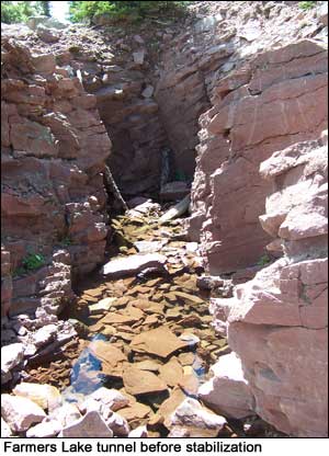 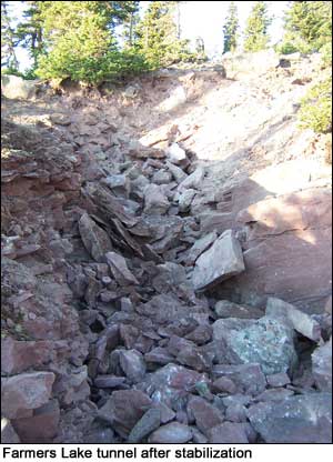
National Register Determination: The historic Farmers Lake Tunnel is a significant individual resource and is a component of a much larger irrigation network. The Farmers Tunnel and its associated structures are unique among all of the reservoir structures in the High Uintas Wilderness Area. Although minor modern modifications to maintain the tunnel and its intake facilities were made, these improvements were done in keeping with the tunnel’s general historic feeling.
The historic tunnel at Farmers Lake was evaluated in 1985 for eligibility to the National Register of Historic Places and was determined eligible under Criteria A (associated with events that have made a significant contribution to the broad patterns of our history) and C (embodies the distinctive characteristic of a type, period, or method of construction).
For a full description of Farmers Lake tunnel, [click here to download the Cultural Resource Inventory of Farmers, Deer, White Miller, East Timothy, Water Lily, Five Point, Drive, Bluebell and Superior Lakes Report.][ Click here to link to Historic American Building Survey/Historic American Engineering Record (HABS/HAER) documentation and archival photos.]
Stabilization Process: Farmer's tunnel was drilled 300 feet long and 3 feet high through a terminal moraine to drain water from the lake. This dropped the natural lake’s level several vertical feet. The stabilization process included removing an historic log trash rack/cribbed structure atop the shaft to the tunnel, which prevented floating debris from entering and blocking the tunnel at its intake. Outlets works were removed and the outlet tunnel and air shafts that were cut through rock moraine were plugged. Crews filled in the outlet and inlet area, as well as the vertical airshafts, by hand with rock as well as they could, but the entire tunnel was not plugged. The work was completed in September 2006.
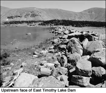
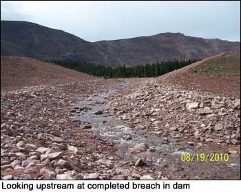
EAST TIMOTHY LAKE DAM: Dam Completed in 1951 - Stabilization Completed in 2010 [PHOTOS]
 Statistics (before stabilization) Statistics (before stabilization)
Location: 8.4 miles north of Swift Creek Campground
Elevation: 11,000 feet
Dam Length: 1,390 feet
Dam Height: 34 feet
Dam Width: 15 feet
Dam Type: Earth-fill dam with stone rip-rap facing
Dam Builder: Swift Creek Irrigation Company
Reservoir Size: 43.6 acres; 569 acre-foot capacity
Maximum Reservoir Drawdown: 19 vertical feet
History: Local farmer Brigham Timothy had water rights to East Timothy Lake and privately funded the construction of a simple 12 by 18-foot sod dam across East Timothy Lake sometime before 1920. Timothy's water rights were later transferred to the Swift Creek Reservoir Company, which became the Moon Lake Water Users Association.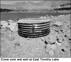
The Association later replaced the dam that was financed by Brigham Timothy with an earthen-fill dam in 1951. The dam closely resembled those constructed in the 1910s and 20s in keeping with the style and type of architecture associated with the formative years of water impoundment in the High Uintas. However, during dam construction earth was borrowed from both the upstream and downstream toes of the dam, which disturbed the natural seal of the ground resulting in widespread seepage and a high probability of structural failure. The lake was maintained at the maximum drawdown level to avoid structural failure.
National Register Determination: The historic East Timothy Lake Dam is a significant individual resource and is a component of a much larger irrigation network. Although modern modifications to maintain the dam were made, such as the replacement of the outlet works, these improvements were done in keeping with the dam’s general historic feeling.
The historic dam at East Timothy Lake was evaluated in 1985 for eligibility to the National Register of Historic Places and was determined eligible under Criteria A (associated with events that have made a significant contribution to the broad patterns of our history) and C (embodies the distinctive characteristic of a type, period, or method of construction). For a full description of East Timothy Lake Dam, [click here to download the Cultural Resource Inventory of Farmers, Deer, White Miller, East Timothy, Water Lily, Five Point, Drive, Bluebell and Superior Lakes Report.][ Click here for record documentation and archival photos in the Historic American Buildings Survey/Historic American Engineering Record (HABS/HAER).]
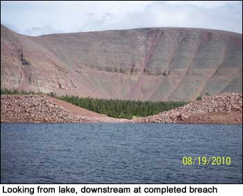 Stabilization Process: Work to stabilize East Timothy Lake was completed in August 2010. The process required excavating a v-shaped notch in the dam using trackhoes and skid-steers. Forest Service Blasters drilled and set charge holes for
fracturing large rock too large to be moved with the equipment. The existing headwall structure and concrete were removed and a new steel structure with head gate was installed to the upstream end of the outlet pipe. The downstream end of the outlet pipe was grouted and a sand filter and pea gravel drain was installed. The existing outlet channel was rerouted back to its historical alignment and a new outlet channel was constructed. Rip-rap was replaced throughout the breach and new channel. The old outlet channel was filled with native material. Stabilization Process: Work to stabilize East Timothy Lake was completed in August 2010. The process required excavating a v-shaped notch in the dam using trackhoes and skid-steers. Forest Service Blasters drilled and set charge holes for
fracturing large rock too large to be moved with the equipment. The existing headwall structure and concrete were removed and a new steel structure with head gate was installed to the upstream end of the outlet pipe. The downstream end of the outlet pipe was grouted and a sand filter and pea gravel drain was installed. The existing outlet channel was rerouted back to its historical alignment and a new outlet channel was constructed. Rip-rap was replaced throughout the breach and new channel. The old outlet channel was filled with native material.
|