|
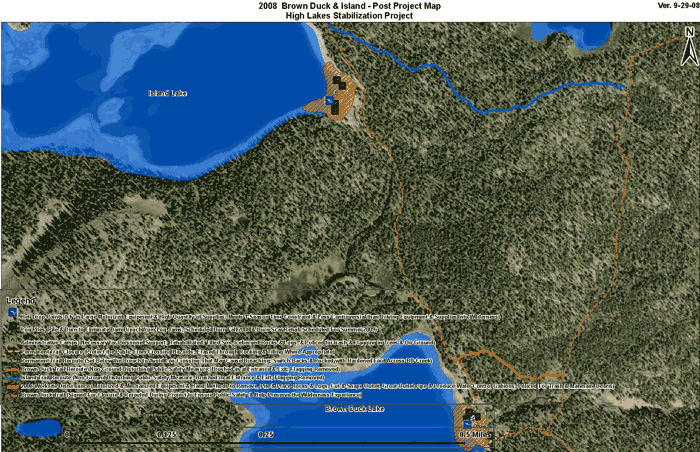
Aerial Photo of Brown Duck Basin
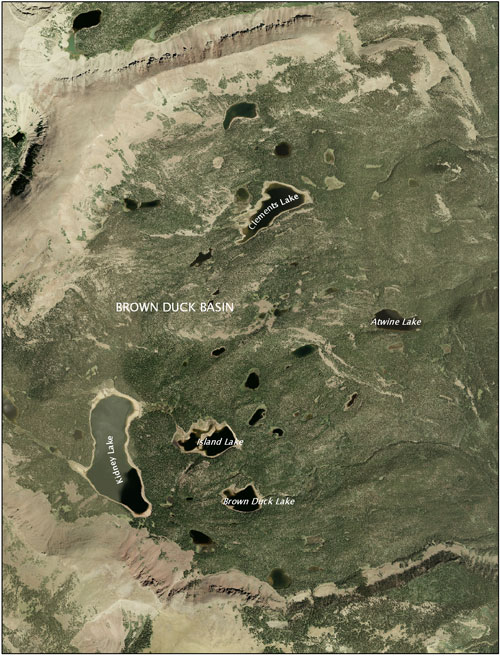 Brown Duck Basin lakes such as Clements, Island, Kidney and Brown Duck were once natural glacial lakes. In the early 1900s they were selected to store irrigation water for the Uinta Basin and all were impounded by the 1920s. The dams were significant individual resources, as well as components of a much larger irrigation network. They are monuments to the pioneering efforts of the Dry Gulch Irrigation Company and the Farnsworth Canal & Reservoir Company to increase the Uinta Basin’s agricultural potential. Both companies played prominent roles in the Basin's economic growth and development. Brown Duck Basin lakes such as Clements, Island, Kidney and Brown Duck were once natural glacial lakes. In the early 1900s they were selected to store irrigation water for the Uinta Basin and all were impounded by the 1920s. The dams were significant individual resources, as well as components of a much larger irrigation network. They are monuments to the pioneering efforts of the Dry Gulch Irrigation Company and the Farnsworth Canal & Reservoir Company to increase the Uinta Basin’s agricultural potential. Both companies played prominent roles in the Basin's economic growth and development.
Although minor modifications were made, mostly in 1977, to the outlet works of the dams, improvements were done in keeping with their historic feeling. They maintained their form and function, providing increased flow to an historic irrigation system, through 2006.
The dams embody a style and type of architecture associated with the formative years of water impoundment in the High Uintas. They were evaluated in 1985 and 1986 for eligibility to the National Register of Historic Places and determined eligible under Criteria A (associated with events that made a significant contribution to the broad patterns of our history) and C (embodies the distinctive characteristic of a type, period, or method of construction).
 Due to substantial deterioration and risk of eventual failure of the dams, Clements, Island, Kidney and Brown Duck reservoirs were breached and stabilized by 2009 to assure safe conditions and to restore approximate natural lake levels. In an effort to mitigate the adverse effects on the cultural resources, substantial documentation of these dams with archival photography was carried out. It was also required that a portion of these dams remain intact. Interpretive displays reflecting the rich prehistory and history of the High Uintas, particularly Brown Duck Basin, were developed and placed at the Lake Fork trailhead located near Moon Lake Dam. Due to substantial deterioration and risk of eventual failure of the dams, Clements, Island, Kidney and Brown Duck reservoirs were breached and stabilized by 2009 to assure safe conditions and to restore approximate natural lake levels. In an effort to mitigate the adverse effects on the cultural resources, substantial documentation of these dams with archival photography was carried out. It was also required that a portion of these dams remain intact. Interpretive displays reflecting the rich prehistory and history of the High Uintas, particularly Brown Duck Basin, were developed and placed at the Lake Fork trailhead located near Moon Lake Dam.
Follow the links below to learn more about the history and
stabilization of each reservoir:
CLEMENTS LAKE
ISLAND LAKE
KIDNEY LAKEBROWN DUCK LAKE
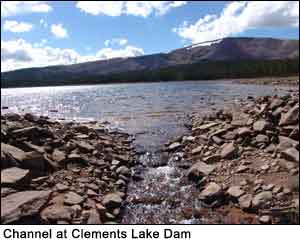
CLEMENTS LAKE: Dam Completed in 1926 - Stabilization Completed in 2007 [PHOTOS]
Statistics (before stabilization)
 Location: Approximately 6 miles northwest of Moon Lake Location: Approximately 6 miles northwest of Moon Lake
Elevation: 10,400 ft - highest reservoir in the Brown Duck Basin
Dam Length: 680 ft - longest of all Brown Duck Basin reservoirs
Dam Height: 13 feet
Dam Width: 14 feet
Dam Type: Earth fill with clay core and unique tabular stone riprap facing
Dam Builder: Dry Gulch Irrigation Company
Reservoir Size: 80.5 acres; 649 acre-foot capacity
Maximum Reservoir Drawdown: 13 vertical feet 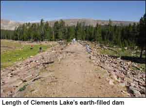
History: Dry Gulch Irrigation Company (Dry Gulch) was granted first rights to store water within the Lake Fork Watershed, but it wasn't until a decade later (1919) that Dry Gulch began developing its claims. To prove their claim, in 1921 Dry Gulch built a small log dam across the natural outlet on the east end of Clements Lake, making it the highest reservoir in the existing Lake Fork watershed storage system. The small dam proved sufficient only to secure Dry Gulch’s interests in the watershed and a larger, formal dam would later be built to utilize Clements Lake to its fullest storage potential.
In 1926, Dry Gulch contracted engineer Louis Galloway to survey the proposed Clements Dam location and plan a pack trail from the Moon Lake trailhead to the dam site (Fraser et al. 1989:71). Galloway’s assistant, Pete Wall, received the contract to construct the dam at Clements Lake.
The Clements Lake Dam built by Dry Gulch is very similar to those built by Farnsworth Canal and Reservoir Company at Brown Duck, Kidney, and Island Lakes. Dry Gulch followed the same strategy for blasting, excavation, foundation placement, and gathering of borrow materials. Improvements made to the Farnsworth design, however, include the patterned placement of tabular stone facing as armor to the upstream face of the dam and construction of an overflow spillway directing overflow well away from the main dam structure.
 National Register Determination: For a full description of Clements Lake Dam, [click here to download the Cultural Resource Inventory of Brown Duck Basin Report]. Click here to view Clements Lake Dam historical documentation and photos in the Historic American Buildings Survey/Historic American Engineering Record (HABS/HAER) National Register Determination: For a full description of Clements Lake Dam, [click here to download the Cultural Resource Inventory of Brown Duck Basin Report]. Click here to view Clements Lake Dam historical documentation and photos in the Historic American Buildings Survey/Historic American Engineering Record (HABS/HAER)
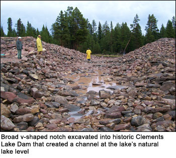
Stabilization Process: The stabilization process required moving stop logs and the unique tabular stone riprap facing that lined the outlet portion of the historic dam. A broad v-shaped notch was then excavated into the dam creating a channel at the lake’s natural lake level, allowing water to move naturally again through the watershed. The dam was left intact on either side of the v-shaped notch. Old headgates were removed and the historic outlet plugged.
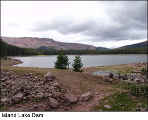
ISLAND LAKE DAM: Dam Completed in 1920 - Stabilization Completed in 2008 [PHOTOS]
 Statistics (before stabilization) Statistics (before stabilization)
Location: Over 4.5 miles north of Miners Gulch Campground
Elevation: 10,250 feet
Dam Length: 250 feet
Dam Height: 20 feet
Dam Width: 18 feet
Dam Type: Earth fill with clay core and stone riprap facing
Dam Builder: Farnsworth Canal and Reservoir Company
Reservoir Size: 60.7 acres; 757 acre-foot capacity
Maximum Reservoir Drawdown: 14 vertical feet
History: As early as 1915, Farnsworth Canal and Reservoir Company filed for water storage rights at Island Lake. By November 1920, a small earthen dam with a clay core was placed at the lake’s outlet. The dam was completed at the tail end of a two-year drought that threatened losses on over 50,000 acres of agricultural fields in the Basin below (Fraser et al. 1989:62). Originally, two smaller natural lakes located on a tributary of the Lake Fork River comprised Island Lake, but were joined together after the dam was built.
National Register Determination: The historic dam at Island Lake is a significant individual resource and is a component of a much larger irrigation network. Although minor modern modifications were made to the outlet works in 1977, these improvements were done in keeping with the general historic feeling of the dam. It has maintained form and function, providing increased flow to an existing historic irrigation system until 2006.
The historic dam at Island Lake was evaluated in 1985 for eligibility to the National Register of Historic Places and was determined eligible under Criteria A (associated with events that have made a significant contribution to the broad patterns of our history) and C (embodies the distinctive characteristic of a type, period, or method of construction). [Click here to download the Cultural Resource Inventory of Brown Duck Basin Report]. Click here to view the Historic American Building Survey/Historic American Engineering Record documentation and archival photos.
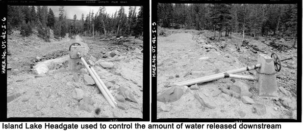
Stabilization Process: Island Lake Dam was stabilized in 2008. The stabilization process required removing stop logs and the stone riprap facing that lined the outlet portion of the historic dam. A broad v-shaped notch was then excavated into the dam, creating a channel at the lakes natural lake level allowing water to move naturally again through the watershed. The dam was left intact on either side on the v-shaped notch. Old headgates were removed and the historic outlet pipe plugged.
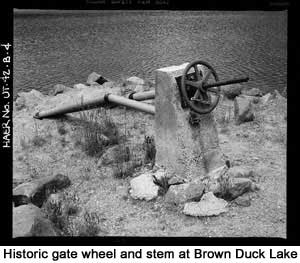
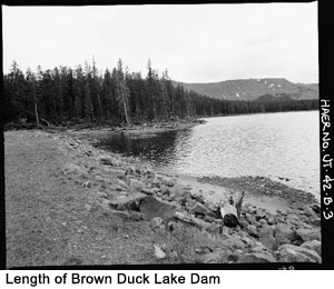
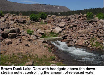
BROWN DUCK LAKE DAM: Dam Completed in 1919 - Stabilization Completed in 2008 [PHOTOS]
 Statistics (before stabilization) Statistics (before stabilization)
Location: Less than 4.5 mi north of Miners Gulch Campground
Elevation: 10,186 feet
Dam Length: 220 feet
Dam Height: 15 feet
Dam Width: 15 feet (top); 25 feet (base)
Dam Type: Earth fill with clay core and stone riprap facing
Dam Builder: Farnsworth Canal and Reservoir Company
Reservoir Size: 36.1 acres; 268 acre-foot capacity
Maximum Reservoir Drawdown: 10 vertical feet
History: As early as 1915, Farnsworth filed for water storage rights at Brown Duck Lake. By November 1919, a small earthen dam with a clay core was placed at the lake’s outlet. The dam was completed at the tail end of a two-year drought that threatened losses on over 50,000 acres of agricultural fields in the Basin below (Fraser et al. 1989:62). Brown Duck Lake Dam is the smallest of the reservoirs in the Brown Duck Basin . The dam was breached in 1968, altering the dam’s integrity. The dam was not repaired and has not functioned as agricultural storage since that time.
National Register Determination: The historic dam at Brown Duck Lake is a significant individual resource and is a component of a much larger irrigation network. While minor modern modifications have been made to the outlet works in 1977, these improvements were done in keeping with the general historic feeling of the dam. The dam has maintained its form and function, providing increased flow to an existing historic irrigation system, through 2007. [Click here to download the Cultural Resource Inventory of Brown Duck Basin Report]. Click here to view the Historic American Building Survey/Historic American Engineering Record documentation and archival photos.
Stabilization Process: The stabilization process required moving stop logs and the stone riprap facing that lined the outlet portion of the historic dam. A v-shaped notch was then excavated into the dam, leaving portions of the dam creating a channel at the lakes natural lake level allowing water to move naturally again through the watershed. The dam was left intact on either side on the v-shaped notch. Old headgates were removed and the historic outlet pipe was plugged.
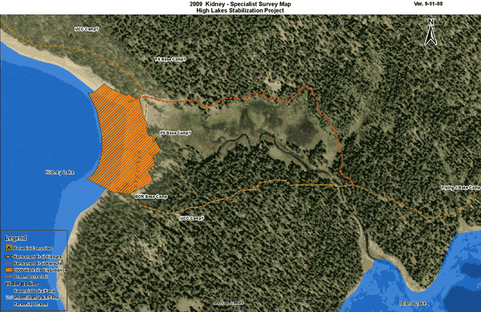
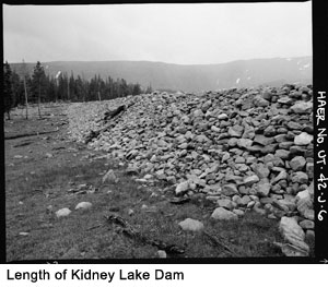
KIDNEY LAKE DAM: Dam Completed in 1920 - Stabilization Completed in 2009 [PHOTOS]
 Statistics (before stabilization) Statistics (before stabilization)
Location: Over 4.5 miles north of Miners Gulch Campground
Elevation: 10,267 feet
Dam Length: 630 feet
Dam Height: 24 feet
Dam Width: 14 feet (top); 75 feet (base)
Dam Type: Earth fill with clay core and stone riprap facing
Dam Builder: Farnsworth Canal and Reservoir Company
Reservoir Size: 194.2 acres; 3,288 acre-foot capacity
Maximum Reservoir Drawdown: 20 vertical feet
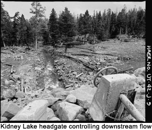
History: As early as 1915, Farnsworth Canal and Reservoir Company filed for water storage rights at Kidney Lake. By November 1920, a small earthen dam with a clay core was placed at the lake's outlet. The dam was completed at the tail end of a two-year drought that threatened losses on over 50,000 acres of agricultural fields in the Basin below (Fraser et al. 1989:62). The dam is the largest of the reservoirs in the Brown Duck Basin . The original outlet works along with a cribbed log structure were replaced in 1977 with an inclined steel pipe outlet and screw.
National Register Determination: The historic dam at Kidney Lake is a significant individual resource and is a component of a much larger irrigation network. While minor modern modifications were made to the outlet works in 1977, these improvements were done in keeping with the general historic feeling of Kidney Lake dam. The dam has maintained its form and function, providing increased flow to an existing historic irrigation system, through 2007. The historic dam at Kidney Lake was evaluated in 1985 for eligibility to the National Register of Historic Places and was determined eligible under Criteria A (associated with events that have made a significant contribution to the broad patterns of our history) and C (embodies the distinctive characteristic of a type, period, or method of construction). [Click here to download the Cultural Resource Inventory of Brown Duck Basin Report]. Click here to view the Historic American Building Survey/Historic American Engineering Record documentation and archival photos.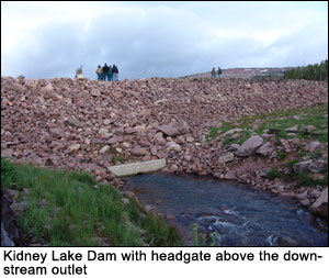
Stabilization Process: Kidney Lake Dam was stabilized in 2009. The stabilization process required removing stop logs and the stone riprap facing that lined the outlet portion of the historic dam. A v-shaped notch was then excavated into the dam, leaving portions of the dam creating a channel at the lakes natural lake level allowing water to move naturally again through the watershed. The dam was left intact on either side of the v-shaped notch. Old headgates were removed and the historic outlet pipe was plugged.
|