|
The Provo River, located in Summit,
Wasatch and Utah Counties, Utah, is
extensively used as a source for
domestic drinking water, irrigation
water, and hydroelectric power
production and supports a high quality sport fishery. The lower portion of the
Provo River, between the mouth of Provo
Canyon and Utah Lake, is heavily
diverted for irrigation purposes. There
are eight diversion structures on the
Provo River from the Murdock
Diversion Dam, near the mouth of Provo
Canyon, to Utah Lake. Diversion structures used to divert the
flows of the Provo River into water
delivery systems are often barriers to
upstream fish migration. Modification, including combining, relocating, redesigning and reconstruction, of the lower Provo River diversions is needed to provide unimpaired fish migration, particularly for June sucker, an endangered fish species.
The
Provo River provides habitat for
many aquatic species, including the June
sucker, a fish
native to Utah Lake. Historically, the June sucker used the lower portion of the
Provo River for spawning habitat.
However, along with many other factors,
the diversion and alteration of Provo River flows have significantly
impacted this species. On April 30,
1986, the U.S. Fish and Wildlife Service
listed June sucker as
endangered and designated the
lower 4.9 miles of the Provo River as
critical habitat. The Fort Field
Diversion, the lowest diversion on the
Provo River and the first diversion
encountered by spawning June sucker,
often restricts their spawning to only the
lowest 3.8 miles of the Provo River. The upper 1.1 miles of the
4.9-mile reach designated as critical
habitat is often inaccessible during May
and June when June sucker spawn.
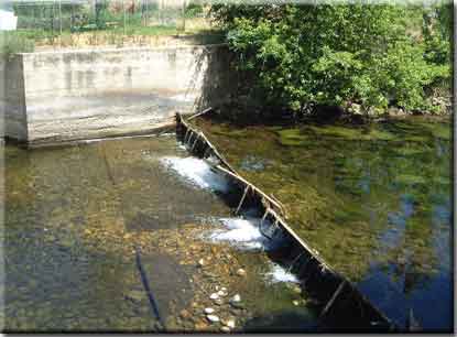
A study to evaluate lower Provo River diversion dams for potential modification was completed in 2001 [Click here to download the Lower Provo River Diversion Dams Evaluation Report, October 2001]. It evaluated the eight structures in terms of their ability to bypass instream flows, impacts to fish migration, effects on hydrology and sediment transport, and effects on riparian vegetation. One goal is to expand the spawning area for the endangered June sucker and other fishes. Other goals include facilitating fish migration and providing a mechanism to ensure minimum instream flows can bypass the diversion dams. The study's conclusions are being used to explore structure modification options. Different structures will need different approaches due to the wide range of drops associated with each.
The study identified the Fort Field Diversion, which is located approximately 3.8 miles upstream of Utah Lake, as the first barrier that should be made 100 percent passable. In March 2008, a Decision Notice and Finding of No Significant Impact was made on a final Environmental Assessment that analyzed impacts of reconstructing the Fort Field Diversion structure. The project will provide unimpaired fish passage even in low flow conditions while meeting the following needs: maintain the ability to meet
diversion requirements for canal companies and legal water users who divert water from the river at the Fort Field Diversion; provide capability for accurate, real-time bypass and
measurement of instream flows; minimize disruption to and/or restore natural stream channel and flow characteristics and riparian and wetland habitats; and, provide for low operation and
maintenance costs and simplicity.
A new diversion will be built in the same location as the existing Fort Field Diversion structure. Work began on November 19, 2008 by replacing a concrete headwall and a short section of pipeline that supplies irrigation water. The pipeline is located under the Provo River Parkway Trail near a KOA campground. Fort Field reconstruction will continue in fall 2009 and will be completed before the end of the year. The new structure will consist of an existing kick-leg dam and concrete sill that will remain in place and will be incorporated into a constructed cobble bar. The cobble bar will begin approximately 200 feet upstream of the existing sill and will angle from the north bank of the river towards the sluiceway located on the south bank. The cobble bar will consist of boulders and large cobble “keyed” into the river bed. As the cobble bar extends to the south and downstream it will increase in elevation until it reaches the existing sill and kick-leg dam at which point the top of the cobble bar will be at the same elevation as the top of the boards on the kick-leg dam. It will then gradually decrease in elevation and recess back towards the north bank until it reaches the existing river channel bed.
|