|
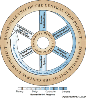
The Utah Lake Drainage Basin Water Delivery System (ULS) is the final component of the Bonneville Unit of the Central Utah Project. Its goals are to develop, convey and deliver remaining Bonneville Unit water supply from Strawberry Reservoir and other sources to the Wasatch Front Area for municipal and industrial uses and temporary agricultural supply; and to complete remaining environmental commitments associated with previously constructed systems of the Bonneville Unit. The Mitigation Commission, Central Utah Water Conservancy District (District) and U.S. Department of the Interior (DOI) are joint-lead agencies planning and implementing the project. [Click here to link to the Districts ULS web page]
Preliminary informal scoping was initiated on the ULS
in September 2000; potential water users were requested
to submit information identifying their need for CUP water.
(Scoping is the process by which agencies and the public
collaborate to determine the extent of issues and alternatives
to be examined in an Environmental Impact Statement.) A public
scoping meeting regarding water needs and assessments was
held in October 2001. Meetings were held with public
agencies in December and January 2002 to
discuss remaining Bonneville Unit environmental commitments
that
could be affected by decisions made during ULS development.
Formal public scoping meetings were held in February 2002
to present ULS water delivery concepts to the public.
A draft Environmental Impact
Statement (EIS) was released for public review
and comment in March 2004. A final EIS [Click
here to link to District's ULS environmental impact page
for more information]
has been issued for which the Mitigation Commission signed
a Record of Decision
on January 27, 2005 to implement the proposed action, the
Spanish Fork CanyonProvo Reservoir Canal Alternative. This will provide an average of 16,000 acre-feet of supplemental water annually to be delivered to Utah Lake via the Provo River.
The Mitigation Commission, through this Decision, approves
completion of the Utah Lake System through the combined efforts
of the Mitigation Commission, the District, and DOI. The system
will provide project water for municipal and industrial
purposes, irrigation, hydroelectric power, fish
and wildlife, and recreation.
Completing remaining environmental
commitments of the Bonneville Unit is one ULS goal for which
the Mitigation Commission and joint-lead agencies are responsible.
Thus, a list of remaining
commitments has been prepared in coordination with public
resource agencies.
The following are included in the list:
- Continue to acquire water shares from irrigation companies to provide flows in the lower Provo River to meet the 75 cfs target flow. (This ongoing.)
- Provide 3,300 acre-feet of irrigation company shares of water to flow unregulated toward the 75 cfs target flow in the lower Provo (ongoing).
(Provo River instream flows will help aquatic species, particularly the June sucker.
Progress on recovery of the endangered June sucker, a fish native only to Utah Lake,
is also among remaining Bonneville Unit environmental commitments. The Mitigation Commission is working with the DOI, District and
other water agencies on June sucker recovery efforts.)
- Initiate a study to determine the feasibility of providing fish passage or removing the Fort Field Diversion Dam on the lower Provo River for
June sucker spawning and rearing; implement if feasible. (Study completed - click here to download. Project initiated in 2008.)
- Provide 10 acres of the 85-acre Mona Spring Wetland Unit that was acquired for protection for mitigation of 1.03 acres of non-jurisdictional
permanent wetland loss and 0.27 acres of temporary wetland impacts. (This is completed.)
- Monitor Ute ladies'-tresses orchid in Spanish Fork Canyon for a number of years. If monitoring results exceed pre-set critical values for orchid populations in Spanish Fork Canyon, management guidelines may be implemented to compensate for impacts.(This is ongoing in conjunction with monitoring requirements of the Diamond Fork Water Delivery System.)
- To offset impacts to leatherside chub, a sensitive fish species in Utah, cooperating agencies will support the Utah Division of Wildlife Resources in evaluating population and habitat status, or determining threat and/or identifying conservation actions that could protect and where approriate enhance leatherside chub habitat. In support of this commitment, a scoping notice was released in March 2011, to gain public input on a proposal to construct a fish barrier in Main Creek, a Provo River tributary that runs through Wallsburg, Wasatch County, Utah. The barrier would help protect a significant population of Southern leatherside chub from predation, competition and hybridization with nonnative fish from Deer Creek Reservoir. [Click here to download the public scoping document.]
In July 2015, the Mitigation Commission, Central Utah Water Conservancy District (District), and U.S. Department of the Interior released an Environmental Assessment (EA) to analyze environmental impacts of realigning the planned Orem Reach 2 segment of the Spanish ForkProvo Reservoir Canal Pipeline located near the Olmsted Hydroelectric Power Plant. The proposed project is located near the mouth of Provo Canyon, and is a component of the ULS. [Click here to download the EA].
The Proposed Action identified in the EA would realign the planned route of the ULS Orem Reach 2 pipeline from the Provo River Flow Control Structure. The proposed pipe alignment would run along the Olmsted Hydroelectric Power Plant access road to the planned Olmsted Hydroelectric Power Plant. It would then use the planned Olmsted penstocks and rock tunnel (both to be replaced as part of the Olmsted Hydroelectric Power Plant Replacement Project) and flowline to connect to the Alpine Aqueduct at the Districts existing 10 million gallon (MG) reservoir. The Proposed Action provides an opportunity to generate hydroelectric power on the ULS supplemental water delivered to the Provo River through the planned Olmsted Hydroelectric Power Plant; it additionally includes construction of a secondary access road into the Olmsted Hydroelectric Power Plant.
|