 Today
less than 1% of Utah's total land is wetlands. Seventy-five percent of
these remaining wetlands, approximately 400,000 acres, are part of the
Greater Great Salt Lake Ecosystem. This wetland ecosystem is known internationally
for its importance to migrating shorebirds and waterfowl, not to mention
aquatic and terrestrial wildlife and other avian species on the move during
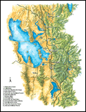
seasonal migrations. The Greater Great Salt Lake Ecosystem (click on map at left
to view enlarged version) encompasses the area from Cache Valley, down the Bear River, along
the shore of the
Great Salt Lake, up the Jordan River, around Utah Lake and up the Provo
River to Jordanelle Reservoir. It includes freshwater wetlands, salt water
wetlands, open water, mudflats, and everything in between to support an
incredible diversity of flora and fauna. Today
less than 1% of Utah's total land is wetlands. Seventy-five percent of
these remaining wetlands, approximately 400,000 acres, are part of the
Greater Great Salt Lake Ecosystem. This wetland ecosystem is known internationally
for its importance to migrating shorebirds and waterfowl, not to mention
aquatic and terrestrial wildlife and other avian species on the move during
seasonal migrations. The Greater Great Salt Lake Ecosystem (click on map at left
to view enlarged version) encompasses the area from Cache Valley, down the Bear River, along
the shore of the
Great Salt Lake, up the Jordan River, around Utah Lake and up the Provo
River to Jordanelle Reservoir. It includes freshwater wetlands, salt water
wetlands, open water, mudflats, and everything in between to support an
incredible diversity of flora and fauna.
In 1995, the Mitigation Commission funded a Needs Assessment and Conceptual
Plan for Interpretive Recreation and Education for the Greater Great Salt
Lake Wetlands Ecosystem to help raise public awareness of this resource.
The report identified a gap between the level of importance the public
placed on wetlands and wetlands awareness, and opportunities available
to satisfy those needs. To facilitate an interpretive recreation and education
master plan that identifies how to reduce that gap for the Greater Great
Salt Lake Ecosystem wetlands, the Commission helped fund and participated
in developing a wetlands education plan.
The Plan is entitled "Connections: A Master Plan for Wetlands Education
in the Greater Great Salt Lake Ecosystem." It identifies diverse audiences,
important messages, and over seventy message delivery ideas appropriate
for each audience. The Plan may be viewed on-line at www.utahbotanicalcenter.org.
The Utah
Botanical Center, which is an
extension of Utah State University, has assumed responsibility for managing
the wetlands ecosystem education plan that has been integrated into
the Utah Wetlands Interpretive Network (UWIN).
The
Network includes 13 accessible wetland sites identified by a UWIN  symbol that
provide wetlands education and refer visitors to other sites within the network
(click on symbol or on map above to enlarge and view site locations). symbol that
provide wetlands education and refer visitors to other sites within the network
(click on symbol or on map above to enlarge and view site locations).
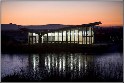
The Commission's partnership with the Utah Botanical Center includes Commission funded construction in 2005, 2006 and 2008 of portions of the Center's proposed wetlands education facilities. Moreover, the
American Recovery and Reinvestment Act of 2009 provided the opportunity to complete
installation of solar panels, a trail and boardwalks, and native vegetation at the Center's
Wetlands Discovery Point. The Wetlands Discovery Point is a state-of-the-art classroom located adjacent to constructed wetlands. It received the Leadership in Energy and Environmental Design
Platinum certification, the highest ranking awarded by the U.S. Green Building Council.
|