Diamond Fork and Sixth Water Aquatic and Riparian Habitat Restoration
Left space of pagetop header navigationLink to return to Home PageLink to PRRP PageLink to projects by watershed pageLink to Wetlands Projects PageLink to LDWPLink to Native Species PageRight space of pagetop header navigation
Big Left space of navigation section
Small Left space of navigation section
Selection Marker ImageMore About Diamond Fork
Selection Marker ImageDiamond Fork Mitigation
Selection Marker ImageDiamond Fork Area Assessment
Selection Marker ImageAquatic and Riparian Habitat Restoration
Selection Marker ImageDiamond Fork Water Quality and Flow Study
Selection Marker ImageDiamond Fork Photo Gallery

Integral to the Commission's program in Diamond Fork is restoring Sixth Water Creek, from the West Portal to the Sixth Water Aqueduct, and Diamond Fork Creek, from the Diamond Fork pipeline outlet to the Spanish Fork River in Spanish Fork Canyon. These creeks were adversely affected by unnaturally high flows resulting from streamflow imported to the basin from Strawberry Reservoir. These trans-basin diversions began in 1916 and continued until 2004, when a system of pipelines and tunnels (the Diamond Fork System) was completed as part of the Central Utah Project to carry the imported water to the confluence of Diamond Fork Creek and the Spanish Fork River.

When the Utah Lake Drainage Basin Water Delivery System (ULS) is complete, this CUP water will continue through piplines, to south Utah County and North Utah County. [Click here to learn more about the Utah Lake Drainage Basin Water Delivery System.]

Since completion of the Diamond Fork System in 2004, the river has shown a remarkable trend toward recovery. Channels have narrowed in many locations and the riparian vegetation has returned along streambanks. Although the trend toward recovery is promising, some locations remain where the river is straight and somewhat devoid of good aquatic habitat diversity. Other areas along the floodplain have been cleared and leveled for agricultural purposes and/or grazed heavily and could benefit from restoration activities.

As part of restoration planning, the Commission and its partners committed to develop a monitoring program to evaluate responses of stream and riparian conditions to reduced flow regimes produced by the completed System. This planning effort was initiated in late 2004 and will carry on for the next several years. [Click here to link to more information about mitigation monitoring in Diamond Fork.] Moreover, the Commission and its partners developed a design to further improve aquatic, riparian and wetland habitat on mitigation lands near the mouth of Diamond Fork Canyon and on a small portion of land adjacent to Uinta National Forest land.

The restoration project will increase sinuosity and promote increased channel complexity in lower Diamond Fork Creek; create and restore wetlands; and increase vegetatative diversity of upland areas. [Click here to download the Draft Conceptual Design Proposal for restoring Lower Diamond Fork Creek.]

National Environmental Policy Act analysis was completed and a stream alteration permit was obtained for the project in 2008. [Click here to download the Decision Memo for the lower Diamond Fork restoration project.]

The project area begins at Highway 6, near the confluence with the Spanish Fork River, and extends upstream approximately 9,000 feet. This section of stream was determined to offer the best location for immediate, active restoration measures.

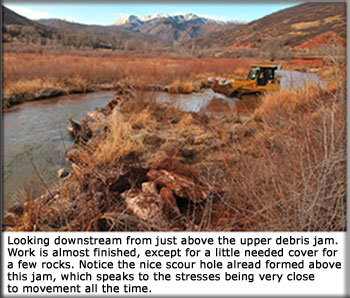
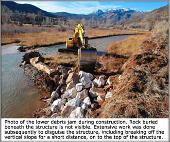
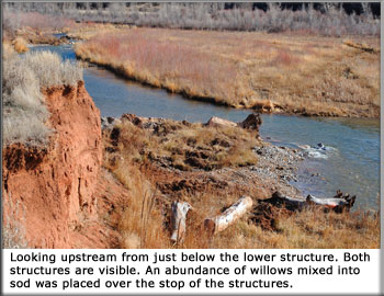
Main channel work in this area consisted of introducing woody debris to promote lateral movement of the channel. This was completed in the fall 2008. Large rocks and logs were put in the channel to force the creek to flow around two debris jams (see photos, right). This is intended to create a more sinuous channel with increased water depth and better aquatic habitat.

If meanders begin to form, the stream is likely to create diversity of habitat without further intervention. This approch limits the degree of disturbance from heavy equipment while still pushing the stream toward a desirable condition.

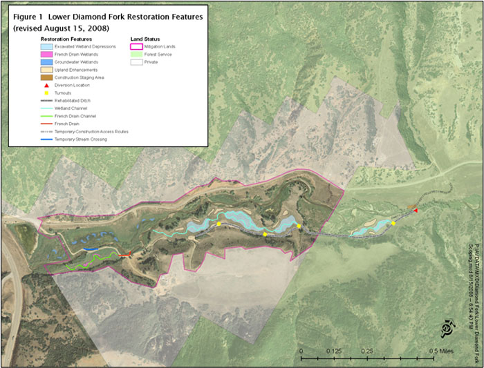
The remainder of the restoration plan (see map below) is to be carried out beginning in May 2009. It includes creating features such as excavated depressions, several small side channels, and a series of small ponds that would provide wetland habitat improvement in a meadow southeast of the channel; rehabilitating an existing ditch system in the project area; and, rebuilding an irrigation diversion system (located on National Forest System lands) that was washed out several years ago during high flows.

Email Link to the Utah Reclamation Mitigation Conservation Commission, urmcc@uc.usbr.govAddress for Utah Reclamation Mitigation Conservation Commission, 230 South 500 East, Suite 230, Salt Lake City, Utah 84102-2045, (801)524-3146, Fax (801)524-3148