|
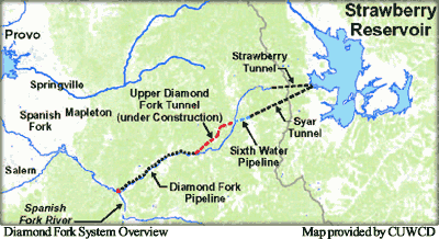
CUP's Diamond Fork Water Delivery System conveys water, diverted from
the Uinta Basin and stored in Strawberry Reservoir,
to the Wasatch Front. It delivers water to Utah Lake
for the Municipal and Industrial system water exchange
and for irrigation in the Spanish Fork area, and for
the Strawberry Valley Project, which was constructed
in the early 1900's. The Diamond Fork System receives
water from Strawberry Reservoir through Syar Tunnel.
The Syar Tunnel replaced a smaller and much older
Strawberry Tunnel, which empties into Sixth Water
Creek farther upstream.
A major feature of the new Diamond
Fork System is to eliminate destructively high flows
of water discharged from Syar Tunnel into Sixth Water,
and subsequently Diamond Fork Creek, by conveying
most of the water through the newly constructed Diamond
Fork Pipeline and through the Upper
Diamond Fork Tunnel, which the Central Utah Water
Conservancy District completed in 2004. Ultimately,
water flows released into Diamond Fork will be managed
at levels allowing restoration of instream and riparian
habitat from the outlet of the old Strawberry Tunnel
down to the Spanish Fork River. [For more information about the Diamond Fork System, click here to link to Central Utah Water Conservancy District's Diamond Fork Project page.]
In addition to restoring aquatic and riparian habitat in Diamond
Fork and Sixth Water, the
Commission is responsible for implementing mitigation commitments
identified in Diamond Fork System environmental decision documents
issued in 1999. A value-engineering review of those documents identified
several minor modifications that would reduce environmental impacts and
construction costs. The Commission, Central Utah Water Conservancy
District, and Department of the Interior prepared an environmental
assessment to evaluate impacts of these modifications.
A decision was made in August 2000 to adopt the environmental
assessment’s proposed modifications. The Commission’s
environmental commitments include monitoring Ute-ladies’
tresses over the next several years [Click here to download the Diamond Fork and Sixth
Water Creeks Riparian Vegetation and Ute Ladies'-tresses
2008 Monitoring Report (pdf 5MB)] and supporting development and implementation of the
June Sucker Recovery Implementation
Program. These commitments track closely with those associated with the Utah Lake Drainage Basin Water Delivery System, which, when completed, will continue to carry the flows out of Diamond Fork, from the confluence with the Spanish Fork River, through a pipeline to Utah Lake.
 Finally, monitoring stream channel responses to
altered flow regimes following completion of the
Diamond Fork System is a key mitigation commitment. The Commission has initiated
a long-term monitoring project, in conjunction with State and Federal agencies, to assess
existing geomorphic and ecologic conditions, monitor stream channel response to the altered flow
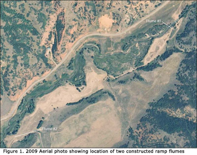
regime, and address aquatic and riparian habitat restoration objectives.A final 2007 Monitoring Report describes the long-term monitoring project and documents the results of the first three years of monitoring for the initial 3-year program. [Click here to download the 2007 Monitoring Report (pdf 4,344 K)] (The 2006 Monitoring Report is documents results of the first two years of monitoring.) A 2011-2012 monitoring effort established four new monitoring sites where no previous channel substrate or macroinvertebrate data had been collected. And as a separate but related effort, sediment transport data were collected at six bridge locations (data had been collected at these same six sites in 2005 and 2006). Results of this monitoring effort are contained in the Sixth Water and Diamond Fork Sediment Transport, Channel Substrate and Benthic Macroinvertebrate Final Monitoring Report October 2013 7.8M. Two reports were completed in August 2010: Instream Flow: A Statistical Approach is a report that summarizes the basic steps used to apply a statistical technique for determining instream flows for the Diamond Fork River; the other report summarizes the installation of two flumes to
allow measurement of flow being diverted from the river, and flow returned to the
river below wetlands (see Figure 1.) [Click here to download the report titled, Flow Measurement Construction:
Installation of Ramp Flumes and Data Loggers.] Finally, monitoring stream channel responses to
altered flow regimes following completion of the
Diamond Fork System is a key mitigation commitment. The Commission has initiated
a long-term monitoring project, in conjunction with State and Federal agencies, to assess
existing geomorphic and ecologic conditions, monitor stream channel response to the altered flow
regime, and address aquatic and riparian habitat restoration objectives.A final 2007 Monitoring Report describes the long-term monitoring project and documents the results of the first three years of monitoring for the initial 3-year program. [Click here to download the 2007 Monitoring Report (pdf 4,344 K)] (The 2006 Monitoring Report is documents results of the first two years of monitoring.) A 2011-2012 monitoring effort established four new monitoring sites where no previous channel substrate or macroinvertebrate data had been collected. And as a separate but related effort, sediment transport data were collected at six bridge locations (data had been collected at these same six sites in 2005 and 2006). Results of this monitoring effort are contained in the Sixth Water and Diamond Fork Sediment Transport, Channel Substrate and Benthic Macroinvertebrate Final Monitoring Report October 2013 7.8M. Two reports were completed in August 2010: Instream Flow: A Statistical Approach is a report that summarizes the basic steps used to apply a statistical technique for determining instream flows for the Diamond Fork River; the other report summarizes the installation of two flumes to
allow measurement of flow being diverted from the river, and flow returned to the
river below wetlands (see Figure 1.) [Click here to download the report titled, Flow Measurement Construction:
Installation of Ramp Flumes and Data Loggers.]
|